A geological wild goose chase
I recently visited the Queen Elizabeth Forest Park with my family. I had enjoyed the park many times as a child, but I had not been back as an adult. I was very much looking forward to descending into the valley and scrambling up the rocks with my children in order to get a closer view of the waterfall at Camadh Laidir, which lies on Allt a’ Mhangam; a burn that flows into the Forth south of Aberfoyle. In my mind it was going to be just as it was when my younger self made the same journey with my own parents and siblings.
The rock scrambling was indeed all the fun I had hoped it would be. My children took great pleasure leaping from rock to rock occasionally getting their feet wet. Their faces were beaming with excitement as we approached our planned destination. Finally, we sat perched on a large boulder looking down on a pool of foaming water and then up at the picturesque waterfall.
Although almost everything was the same as I had remembered there was one thing that was different this time around. Something, that was in plain sight and was not remotely new. The difference was the fact that this time I had noticed.
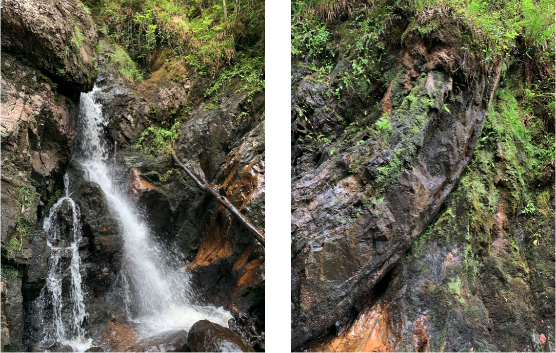
At the base of the waterfall there was a distinct line of curvature in the rocks where those above seemed to be slipping smoothly over those below. It was immediately obvious to me that I was looking at a fault in the rock formation. A point were two sections of crust had been forced together and pushed passed each other many millions of years ago.
It turns out that climbing to the base of the waterfall is not only good fun, but it also affords the opportunity to view a geological feature at close quarters.
A week later we decided to spend Saturday climbing Conic Hill with friends. Although it is not a Munro [a Scottish Hill more than 3,000 feet above sea level], Conic is a scenic location, because it looks down on Loch Lomond and is aligned with the Highland Boundary Fault. As you climb beyond the tree line you can follow the trajectory of the fault to the base of the hill and all the way across Loch Lomond, where the islands of Inchcailloch, Craobh-Innis and Inchmurrin lie on its path.
Thus, climbing Conic is not only an enjoyable hike, but it also provides an excellent opportunity to view a geological feature on a macro scale.
On reaching Conic’s summit and turning to view our accomplishment from several directions it dawned on me that I recognised the landscape. It seemed familiar.
I suddenly realised that in the distance I was looking towards the Queen Elizabeth Forrest park where I had been the previous week. A most intriguing thought then entered my mind. Could it be that the fault I had been looking at close up the week before was somehow related to the fault that I could now see cutting across the landscape in the opposite direction?
On returning home I consulted google maps [other map services are available]. To my great delight I found that I could draw a straight line across Loch Lomond, through Conic Hill and straight to towards Aberfoyle; the small village located just to the south of the waterfall. Frustratingly I required a computer monitor roughly twice the size of the one I have to pick out the precise location of the waterfall when viewing at a macro scale.

Never-the-less I had perhaps discovered that the falls at Camadh Laidir were geologically connected to the Highland boundary fault. Discovered for myself that is; I am quite sure that if correct Geologists would have known this fact for a great many years.
Undeterred by this small detail Google map’s apparent conformation of my discovery brought me considerable delight, because I had spotted the link for myself. In the moment I was perfectly happy to overlook the fact that perhaps this was something I might have known already had I paid more attention in geology class 25 years ago.
After some further time invested in squinting at online maps [belonging to the Ordnance Survey and British Geological Survey] to pick out the watercourse profile at Camadh Laidir, I have reached the conclusion that the waterfall is indeed located on a fault, but one just a little to the north of the actual Highland Boundary fault. Are they related; I really hope so, but I need a proper Geologist to tell me.
Even if they are not strictly related my geological adventure, which was quite unintended, is a reminder that, owing to the four major faults that divide its foundations, Scotland has an incredibly diverse geology squashed into its rather tiny land mass. Is it any wonder that the origins of the subject lie within its boundaries.
Incidentally, for those unacquainted with a civil engineering education geology is one of those subjects that is bolted on to Statics, Materials & Fluid Mechanics. In theory we were supposed to learn something about the make-up and behaviour of the ground, as we could one day be asked to tunnel through it, anchor a building or bridge to it or perhaps restrain it from moving.
It follows that the endearing story of my rather amateur geological wild goose chase counts as an acceptable topic for a blog about Structural Engineering. It has to because I need to tell someone and my family and friends aren’t interested.


No comments:
Post a Comment